## General Map of Narnia and its Neighbors
Here’s the translation: Narnia, Archenland, Calormen, the Wild North and the Eastern Sea on a single original map.
## General Map of Narnia and its Neighbors

The world of Narnia
Explore the map
Zoom in, move around, filter by book or by type of location, then click on a location to read what the books say about it. The list below the map includes the same locations.
Tous les lieux sont affichés.
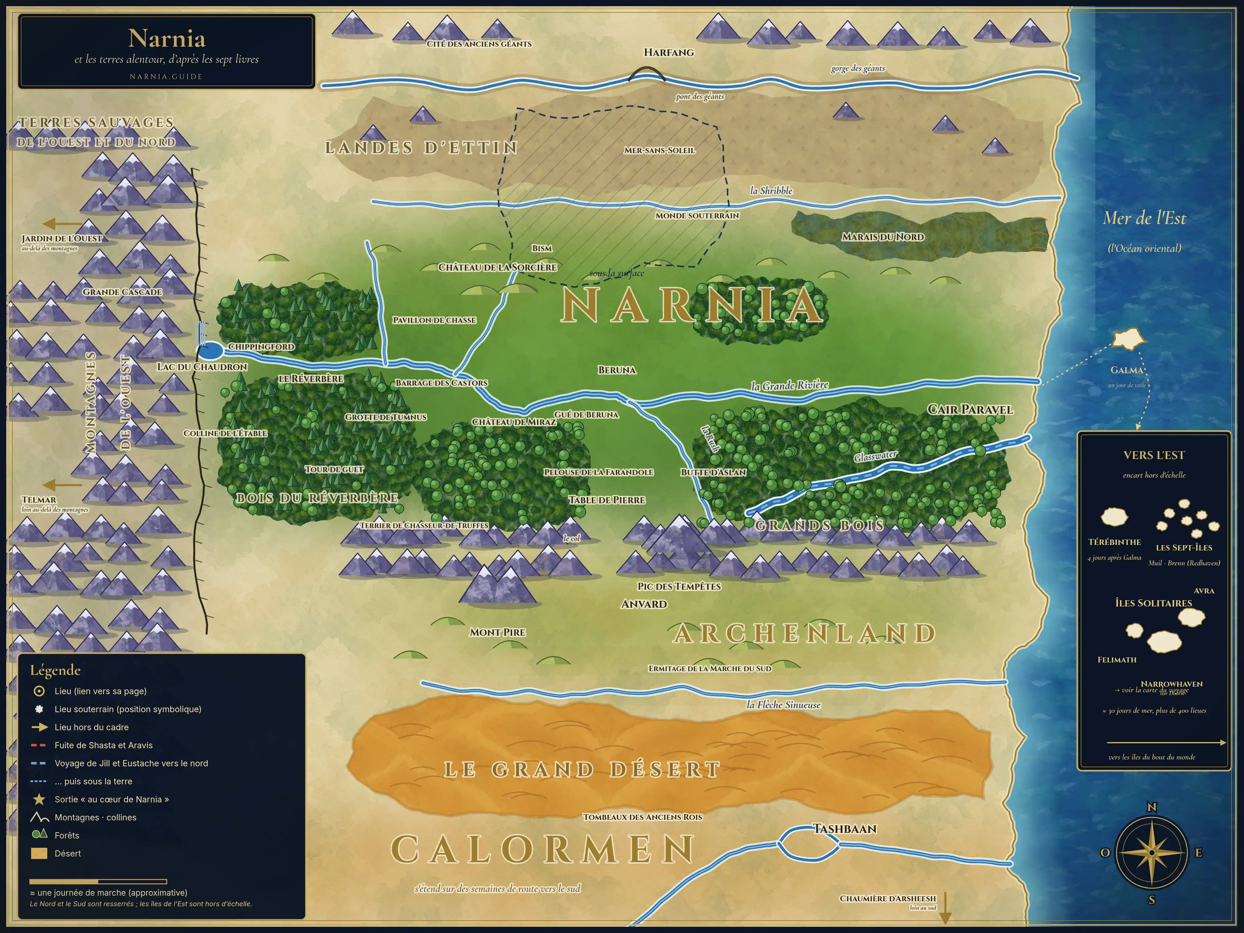
Map of Narnia.guide, drawn from the text of the seven books. Distances are approximate.
Home
Home
The bubbling pool at the foot of the Great Waterfall, at the extreme west of Narnia.
Market town downstream from Lake of the Lanterns.
The Western Wood where the lamp post shines, born from an iron bar planted at Creation.
The fawn's cave, a short walk from the lamppost.
The Hill of the Stable, where the Last Battle is fought.
One of the three towers built to guard the Lamp-post Wood; Tirian's hunting pavilion is further east.
The Beaver's Dam and House, on the frozen river, a day's march from the lamp-post.
The White Witch's house, in a small plain between two hills, north of the river.
The castle of the Telmarine kings, one mile from the Beavers' Dam waterfall.
The Fauns' glade, where Caspian unites the Old Narnians.
The Badger's sett, in the forest at the foot of the Southern Mountains.
The River of Narnia: from the Great Waterfall west to the sea, past Cair Paravel.
The little town at the bridge, on the north bank, where the Ford was located.
The Ford where the river widens; Aslan camps there before the battle.
The Stone Table, on a hill overlooking the river to the south; the sea can be seen in the distance to the east.
The high hill on the Stone Table, at the edge of the Great Woods.
The castle of kings and queens, on its hill, at the mouth of the river.
Regions
The land: the river valley, from the Great Waterfall in the west to the Sea in the East.
The Uncharted Islands to the West (beyond the Waterfall) and to the North (beyond the Shribble).
The small kingdom of Calormen, south of the Narnian mountains.
The Great Desert, between Calormen and Archenland, crossed in one night and one day.
The great empire of the South; it extends far beyond the edge of the map.
The North and the Underworld
The Marshes where Puddleglum lives, between the forest and the sea's dunes, south of the Shribble.
The Land of Giants, north of the Shribble; it takes about ten days to cross.
The ruined city of the ancient giants, beyond the bridge and near Harfang.
The Castle of the Gentle Giants, at the end of the Bridge Road.
The realm of the White Witch, under the earth and under Narnia.
The underground sea that one crosses by boat to reach the Lady's city.
The Really Deep Country, much lower even than Underland.
Archenland, the desert, and Calormen
The castle of King Lune, on the south slope of the pass that leads to Narnia.
The twin-peaked mountain that guides the crossing of the desert; the Dawn Treader's Peak overlooks Anvard to the east.
L'enclos vert of the Hermit, just north of the Shifting Isles.
The beehive-shaped tombs, right at the edge of the desert, west of Tashbaan.
Cair Paravel
Beyond the map's boundaries
The Last Battle
The garden on a green hill, at the end of a blue lake, in the heart of the Western Mountains.
The land of the Telmarines, far beyond the Western Mountains.
The Sea of the East
Galma, one day's sail away; Terebinth and the Seven Isles further to the east.
Felimath, Doorn, and Avra: nearly thirty days and over four hundred leagues from Narnia.
The small white town of Doorn, home to the governor of the Lone Islands.
The voyage to the east extends far beyond this entry: all the islands, from Galma to the end of the world, are on their own map.
Hors de cette carte
Home > Places to the east (beyond the wardrobe)
The mountainous island where Eustace, sleeping on a dragon's treasure, wakes up as a dragon himself. Burnt Island is its small neighbor. — See the map of the Voyage of the Dawn Treader.
The rocky island where the lake turns everything that touches it to gold, awakening Caspian’s and Edmund’s greed—See the map of *The Voyage of the Dawn Treader*.
The island of the magician Coriakin, inhabited by the invisible Duffers, where Lucy reads the spellbook. — See the map of *The Voyage of the Dawn Treader*.
A mass of darkness over the sea, where all dreams, especially nightmares, become real. — See the map of *The Voyage of the Dawn Treader*.
The Island at the End of the World where you find Aslan's Table, always stocked, and the three sleeping lords. — See the map of the Dawn Treader's voyage.
The last sea to the Dawn Treader, covered in white lilies, whose fresh water nourishes like light, and which ends on a motionless wave before the land of Aslan. — See the map of *The Voyage of the Dawn Treader*.
The land of Aslan, beyond the world's end, on mountains higher than all, from where come the calls of Aslan and where arrive those who love him. — See the map of The Voyage of the Dawn Treader.
Home > Beyond Narnia
A peaceful and slumbering wood filled with pools that are each a gateway to a world. — Wood between the Worlds.
The dead capital of a lifeless world, where Queen Jadis spoke the Deplorable Word and destroyed all life. — Other world (The Magician's Nephew).
The country station where the four Pevensies are summoned to Narnia by Susan's horn. — Our world (England).
The South Sea of our world through which the ancestors of the Telmarines passed, and the door Aslan opens for their return. — South Sea of our world
Our world — England, both Victorian and modern, and real locations mentioned throughout the books. — Home.
The old country house of Digory Kirke, where the Pevensie children are sent in 1940 and where the wardrobe is located. — Our world.
Our world (Eustace and Jill's school)
The London house where Digory, his sick mother, Aunt Letty, and Uncle Andrew live, connected to Polly's house by a tunnel under the roof. — Our world (London)
The name Aslan gives to our world and to old Narnia: shadows of reality, compared to the true country. — Our world, seen from the real Narnia.
Symbolic Places
A flat world, created by Aslan, which includes Narnia, Archenland, Calormen, the Eastern Seas, and at its furthest reaches, the land of Aslan. — The entire world: corresponds to the whole map.
The Narnia more real and more beautiful than the heroes discover in the land of Aslan after the end of the old one. — Beyond the stable door: no geographical location.
The general map shows the heart of the Narnian world. At the center, Narnia, with the Lantern Waste to the west, the Great River and Cair Paravel on the east coast. To the south, the Archenland mountains, Anvard, and the Dark Mountains, followed by the Great Desert and Calormen with Tashbaan. To the north, the Shribble River, the Marshes, the Ettin Moor, and the Harfang country. To the east, the sea and the first islands.
Original map from Narnia.guide, based on the text from the seven books. Distances are approximate.
Échanges entre lecteurs
Une question, un souvenir de lecture, une idée ? Partagez-les avec les autres lecteurs, dans le respect de la charte des commentaires.
Les commentaires ne sont pas disponibles pour le moment.
Les commentaires sont fermés sur cette page.
Aucun commentaire pour le moment. Soyez la première personne à partager votre avis !
Merci ! Votre commentaire sera visible après relecture.